Saturday, August 29, 2015

Easy Social Ride


After beating myself up for the last two weeks on hard hilly rides that pushed me to the limits and a season of tough rides I wanted a something mindless and easy. I sent out a email to the usually folks and a few people I haven't seen in a while. The response was great and I got more people than expected. It seems the words easy and flat were the key they drew everybody out, even though I am know for understating the difficulty of my rides. I ended up with 10 people. Gen, Laura, Cheryl, Mary, Herb, Jim. Jack. Dave, Joe and Marc.

We started out from the Edinburg parking lot of Mercer park and did this route. Except for a few minor bumps I kept the ride flat. I don't know what our average was but we moved along at a good relaxed pace. I wasn't pushing it or really having to slow down to keep the group together. These are all experienced riders and we have ridden a lot together as a group over the years so it was a very low stress ride that didn't require much from me to keep it together.

There were lots of conversations going on and I got to catch up with people like Herb and Mary who I haven't seen much this year. We stopped at the new Roy's which I haven't been to yet. It has decent food, a good bathroom and the location is central enough to make it a frequent stop for our local rides.

I ended up with 50 miles since I rode in from home. Because of the pace and the good group of people on the ride it was one of the more enjoyable rides this year and a good way to unwind from a hard riding season.

Monday, August 24, 2015

The Highest Point


So I think I broke my insane bike posse. We have had more mechanical issues like broken spokes and tire problems this year  as well as our share of physical problem like people cramping up. There have even been a few crashes. Luckily none were serious(i.e. Jim's face is no worst than it was before) but it has been a tough year.

This weekend was support to be a trip to north Jersey to knock off a few more county high points however the trip fell apart the week before because the few people who wanted join me had to bail. It is always hard to coordinate a weekend trip because everybody has busy lives with responsibilities pulling them in multiple directions.

I was still determined to do at least the ride to High point in Sussex county this weekend because I'm in the best shape I'm going to be in this year and will be taking a couple weeks off the bike for a vacation. So this may be my last chance this year to do this hilly of a ride. I would have done it myself but luckily I got Laura and Marc to join me.

The ride I had planned would visit the high points of Warren and Sussex and would be 66 plus mile ride with close to 6000 ft of climbing. I know that RideWithGPS shows 5100 feet of climbing but it is notoriously low.  The reason the ride was this long and hard was that the Warren and Sussex high points were JUST close enough to do together but were also the two highest high points in state with a lot of hills between them.

The worst part about this ride was the start. Within a few hundred feet of getting on the bike we started a 700 ft 1 mile climb that varied between 10 and 15% grade on Millbrook Rd. I am famous for starting a ride with a tough climb but even I was pissed at me for doing this. Unfortunately this was the only way to get to the Warren County high point.

The actual Warren County high point is on a remote part of the Kittatiny mountains and is in accessible by bike or car so Millbrookd Rd is the closest we could get. My GPS logged 1286 feet at this point which is 314 ft short of the 1600 ft of the official Warren county high point but that was the best we could do with out some back woods hiking.


After the Warren high point we road along the ridge in shaded woods on quiet roads until we emerged on Rt 206. There are not a lot of place to stop for food around here but we were lucky to find a deli to fuel up before the push to Highpoint.


This deli is right next to the Appalachian Trail as the sign clearly shows.

Most of the way to Highpoint was on Sunrise road which is mostly tree covered except for a small section that gave a great view of the valley below. It reminded Laura of the view from Skyline drive and since the view is facing east it would be a good place to be for a sunrise.


A couple more turns and a harder climb than the profile would indicate we were on Deckertown Rd. We were now on the normal route that we took up to Highpoint the last time we went there so Laura and I knew what to expect. It is a slow shallow climb up Sawmill then a short stretch on Rt 23 before we enter the park. We headed right up to the monument which is a mile from the entrance. The only really hard part is the quarter mile up to the monument which has a few brief parts that are 20% grade. It felt a little easier than the last time I did it.

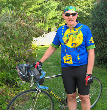
We were definitely a little tired not only with the last climb but with all the hills we came over to get here. The high point picture on the top of the post is the only one I will be in since I wanted to have a picture similar to the last time I was here. I also updated my exhausted Laura picture.


It wasn't a perfectly clear day but the view wasn't bad. After a few more pictures we headed out of the park and back down to the valley. I started to have a few mechanical and physical problems on the way down. The mechanical problem was that my front derailleur would slip into the granny gear when I was in my low gear in the cassette and grinding up a hill. The mountain bike gearing I have on the bike is finicky and needs to be adjusted on a regular basis. I had not done much maintenance on it this year so I guess I was due. It was more annoying than a real problem as I just change my shifting a little to keep it in the middle gear.

The physical problem I had was some leg cramps. I had brought a bottle of gator-aid with me and was drinking as much as I could but I guess the climbing was catching up to me. I stopped and stretched a couple of times and was able to continue on especially now that we were on mostly flat to rolling roads.

I had two planned stops for this ride but when we got to the deli that we always stop at it was closed. Apparently they close on 1 pm on Sundays and I was out of water. We asked some people at a farm stand nearby if they had any water and brought us over to a spigot on their farm to fill up. It is always refreshing to meet helpful people along the road.

With 15 miles to go and only one more real hill to climb the end was near but we were all beat and tired of even the smallest climb at this point. So when we went through the town of Layton and I saw a Greek general store open I decided to stop for a break. I went for a Balaclava because it looked good and wanted something sweet. 5 miles later we were at the last hill.

We did this hill last year and it is a 10 % grade but what really makes it tough is the fact that it is more pot holes than road. I stretched at the bottom to try to prevent any cramps and then turtled up the hill.  From the shape of the road it looks like they didn't bother to patch the holes so you had to really plan out your path to miss the worst of it and not ride off the road.

I made it up with out cramping and was glad when I finally made it back to the car. This may have not been the toughest ride I have every done but it is definitely in the top 5, 4, OK top 3. For the record I promised that I will never ride on again Old Mine Rd by Millbrook Village or do the climb up Millbrook Rd. They are just too beat up and/or steep. I wanted that on the record because I said that we would never do the Millbrook part of Old Mine Rd again when we were here last year and here we are a year later so I wanted to say I mean it this time.

After a little stretching we got back into the car and headed home. I cramped up a little on the way home but it was not bad enough to make me stop and pull over. It was a hard ride but I'm glad I did it.  There are some good road to ride around here so I may be up this way again in the distant future but I need a few weeks of flat roads before I will consider doing hills again.

I will still need to get to north Jersey one more time to get to the Bergen, Passaic and Morris high points so there will be one more hilly ride in my future. I  will probably do that at the end of Sept or beginning of October depending on when I can get some of the insane bike posse sane enough to join me.

Sunday, August 16, 2015

So You Think You Can Climb


Next weekend I am planning on going to high point in Warren, Sussex, Bergen, Passaic and Morris. These will be very hilly rides. To get ready for next weekend Laura did a ride today from Lambertville through the hills in Pennsylvania and NJ around the Delaware. The route was a combination of some roads Blake wanted to explore and a hill Laura wanted to do. We only lost one person (Jim) to attrition (broken spoke) although some of us were feeling a little beat by the time we got to the stop in Milford.

Although the route had only 3200 feet of climbing it felt a lot worst probably because the hills we did climb were steep or long and sometimes both. Or as Laura put it the hills were in nasty little clumps. It was also well above 90 by the time we finally finished.  I was definitely was shot by the time I finished the ride and cramped up on the way home. However part of doing the ride today was to beat my legs up to be ready for next weekend so after some recovery I should have no problem with next weekends ride. 

I have done a lot of climbing this year and think I could tackle any hill I wanted to. That was until I saw the list of hills at this web site http://www.pjammcycling.com/home.html which lists the toughest climbs in the US. Except for Mt Washington I haven't been close to any of these climbs. In a few weeks I will be in Maui so I am definitely going to ride the toughest climb in the US (by car). This site also lists the toughest climbs by state so at least I can claim I climbed one of the toughest climbs in the state. Not all states are listed so maybe next year I might try to find of the toughest climbs in other flatter states like Delaware since my legs may fall.after next weekend.

Saturday, August 8, 2015

Stupid Southern Highpoint Ride

Well at least I didn't kill Dave just his tire. I have had more than my share of physical and mechanical mishaps this year on rides I have been on this year. Some years are just like that.

Although I had planned do a weekend in Cape May the weather forecast and my inability to find a decent hotel made me rethink my plans. Instead I decided to do a ride to the high points of Atlantic, Gloucester, and Camden counties. When I planned out the route it seem like a stupid ride. In order to hit the high points I had to do a double back in order to not go on any major roads and keep the ride around 60 miles.

We started from a park in the middle of Hammonton which had a nice small lake as seen above. I was joined today by Jim, Laura, Jack, Joe and Dave. I was surprised to see Dave since he has been having some problems with his ticker but said that he would be fine in the flat lands we would be riding.And he was although he still complained a lot.

Our first high point was about 4 miles into the ride. This was the high point of Atlantic county which is suppose to be a whole 150 feet but I actually had 160 feed on the GPS.


As you can see Dave is faking being tired after the actual climb which was probably all of 40 feet from the staring point. From here we found some really straight roads as we headed towards Williamstown. When I say straight I mean that the road did not turn by more than 0.001 degrees for almost 5 miles.

Our second high point was in Gloucester county. This one was on a semi busy road north of Williamstown.


The high point was by the Life Church (LifeisHere.org) who's mission is to use religion to help heal sick, addicted, depressed and troubled people. I had 194 feet even though the actual high point which is just to the left of the road is listed at 180 feet. I think some of these high point are higher than expected because the construction of the roads add a few feet to the surface and makes the surrounding area a little higher.

From the Gloucester high point we back tracked down the way we came and made it  to a Wawa in Sicklerville for our only stop. There are not a lot of places to stop in this area so I had to put the stop at mile 20.

A few more really straight roads later we were in Atco and heading to our third high point in Camden county.


The actual high point is in the woods behind a large development. The are still building houses in this development so we have to go through some construction to get there. The path behind Jim, (who always has to take a picture of me taking a high point picture), leads to the actual high point. I had 213 feet here which is really close to the official 219 feet. On NJBikeMap.com Dustin actual has the highest road a few miles away at 167 feet which I think is an error since there are a lot of higher roads near the actual high point.

For those who are observant you noticed that Dave was not in the Camden high point picture. This was kinda my fault. On our way up the hill my saddle bag fell off the bike as it does once a year. Jim managed to swerve around it and Dave missed it with his front wheel but caught it in his back wheel causing him to skid but luckily not fall.


The skid which wasn't that long wore his tire through the canvas and produced a large hole in the tire. Dave and Laura tried to repair the tire with a boot and duck tape but although it held the tube in it was not really safe to ride that way. That meant we had to leave Dave at the side of the road with a promise that we would remember where he was and retrieve him later.

We made a quick 18 mile run back to the start for a total ride of just over 55 miles. Jack and I with Joe following went to retrieve Dave. After which we had to find our way home. We ended up going up Rt 73 which was full of traffic then got on 295 and made it back to Bordentown.

So although we had a stupid route and a mechanical problem we did check 3 more high points off the list. The next set of high points will be a lot high and require a lot more climbing.