Sunday, May 31, 2015

Headwinds, High Points and a Gorilla

This Saturday was my Southern Safari ride to visit the high points of Salem and Cumberland counties. The official high points are 160 and 140 feet respectively so these are some of the lowest high points in the state. Salem and Cumberland counties are mostly farmland and is where the Garden State earns it name. This makes for very flat and open riding. This area is a nice place to ride because there is almost no traffic and no hills to worry about. Because this is mostly open farmland there isn't a lot of interesting things to look at except the odd stream, marshland or lake. It is also not a place you want to ride on a hot sunny day since there is no cover to protect you.

Because this was going to be a long ride where we had an hour drive to the starting point I didn't get a big turn out. It was just Laura, Jack, Ken, and myself. The starting point was in Woodstown which is south east of the middle of nowhere. It was however close enough to 295 to be easy to get to. From there we did a 65 mile ride though Salem and Cumberland county. On paper this looked like a flat and easy route but it turned out to be a little harder than I thought.

First we had a strong headwind for the first 30 miles. Second it was on the humid and hot side but luckily it was mostly cloudy so that kept the temperature from getting too bad. Third although this is a very flat area it had a lot of small ups and downs which added up over the long ride. According to my Delorme GPS the total elevation for the ride was 1600 ft which is a lot considering we spent most of the ride at an altitude of less than 100 feet of sea level.

One of the strange things about riding south of Rt 70 is that it is like being south of the Mason Dixon line. People talk slower with a southern accent. There are lot more pickup trucks than cars and the houses seem a little more run down. This was most evident at our stop in Alloway and Centerton,

On the ride description I suggested that there might be some exotic animal sightings on the ride and I kept my promise by stopping at the Cohanzick Zoo This was NJ's first zoo and although it is just a small county zoo it was worth a quick stop especially since there is no admission fee. We took a quick walk around and got a glimpse of the white tiger which is their main attraction. They also have some small monkeys as well as some other assorted animals.


At the zoo I decided to take the high point picture since I know the high points of Salem and Cumberland would just be on a boring road next to a farm field. They had a Gorilla that made for a good photo op. 

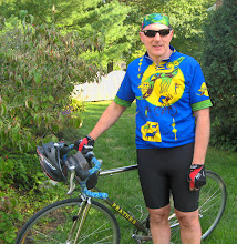
From the zoo we headed mostly north and back towards Woodstown stopping a couple of times to take pictures at or near the high point. I had studied the maps and knew approximately where the high points were based on NJ Bike map but it was so flat that it was hard to tell which bump was the high point. I know we road through it at some point and my GPS read 135 feet at the Cumberland high point which is where the picture below was taken.


For the Salem high point I got 173 feet which is higher than the official 160 feet. It was also in a different road than was marked on NJ Bike map. Again the flatness of the terrain makes it difficult to tell what dirt pile is higher than the other. All that matters is that I can check these two counties off the list.


By the time we were done with the ride we where definitely feeling more tired than expected. The hot weather and wind had taken its toll. It also didn't help that we had two flats (Laura found a piece of metal staple in her rear tire at mile 30 and I had a pinch flat on Compromise Rd where that was more sand and dirt than road).  I also got stung on my tongue by a small bee. Luckily I'm not allergic and didn't experience any swelling.


Next week it is on to some real hills in Somerset county

Sunday, May 24, 2015

Hilly Non Highpoint

I did not have a highpoint ride schedule for this weekend so I decided to do some climbing. This was to get in shape for the hillier highpoint rides and for Bike Virginia. I chose a hilly ride that Blake actually create a couple of years ago an then added a few more hills to get a total of 4000 feet of climbing.

We started from Bulls Island with the usual posse. Jim, Laura, Ron, Marco, and Barry. The first 25 miles are so were on the NJ side of the Delaware. The first few miles were flat as we headed up Lower Creek road to THE NJ Covered Bridge. Then we started climbing. Although the climb up Upper Creek was not the longest or hardest climb it still felt tough. We rode along the ridge for a while with some rolling hills then did another long and tough climb.

At this point we were just above 900 feet which is higher than any highpoint ride we did so far. The payoff though was a 3 mile ride down hill on Hickory Corner Rd. Then down 519 into Milford and over to PA to our rest stop in Black Eddy.

When I told Jim we were stopping in Black Eddy he seemed happy because he likes that rest stop. He then ask does that mean we are going up that really steep hill after the stop. Dumb question. Of course we are going up Bridgeton hill why else would I come this way.

Bridgeton hill is 10-15% grade that goes up about 400 feet. It is a hard climb. I usually do it once a year to see how strong and crazy I am. Its not a fun hill to climb but I made it with out my heart blowing up so it means I am in decent shape but still need some more training to make climbs like this less painful.

The next real climb we had was up Dark Hollow. This is a long 2.5 mile climb with a more or less constant grade of 4%. I actually enjoy this hill because its hard enough to feel like you accomplished something when you get to the top but easy enough to not worry about.

We went through Stover Park again. This time I managed to not loose Jim and Laura. I had planned to go down Fleecy Dale Rd but it was still closed so I had to detour to Green Hill. I had not expected Fleecy Dale to be closed since they have been working on it for 2 years but manage to remember the alternate way down.

By the time we got back to the start we had 52 miles. It was a tough ride but I'm happy with my progress this year and with a little more training should be ready for some of the extreme hilly rides I planning for the future. 

Saturday, May 16, 2015

Ocean/Burlington Highpoint

New Jersey is a pretty flat place once you get south of 195. Today we hit the highpoint in two counties in a 57 mile ride and didn't even break 1400 ft of vertical climbing. The ride was a slight variation of my pineland rides. You can see the route here.

We started in Allentown which is only 9 miles from my house so I decided to ride in and was joined by Jim. This would make the ride 77 miles for me which would be a high for this season for me. Laura, Ed and another rider did me one better by turning the ride into a century.

We all meet at Bruno's Bike shop and were joined by Ron, Jackie, Mike M, Mary and Herb. The weather called for a chance of rain but the radar and forecast looked like it would hold off until the end of the ride. We did have a brief scattered shower at the beginning of the ride and right after the rest stop but it was a minor annoyance and didn't really affect the ride.

The first highpoint we hit was Ocean County which is near the the intersection of 528 and 539. I stopped where the highpoint was according to Dustin's map to get a picture of the GPS but instead of taking another nondescript picture of everybody standing on the grass on the side of the road I decided to take the picture at the New Egypt Speedway which is just down the road and makes a better picture.


We then continued into the pinelands and made our usual stop at the Wawa in Browns Mills before getting a little rained on our way to Pemberton. On the other side of Pemberton we made the climb up to Arney's Mountain which is the highest point in Burlington Country. We stopped for a picture by the Windmill at the corner.


 I guess Mike was getting tired since he took a seat.

As you can see by the elevation both of these highpoints are nothing that would require any real climbing. The actual highpoints for both these counties are also pretty close to the road so although we did not get to the real high points we were with in site of both. When I got home I actually checked the numbers on Dustin's map. For Ocean country he had the elevation on the road on 204 feet and I got 191 which is with in the accuracy of my GPS. I actually think he has the highpoint in the wrong place I think it is on 528 just before the turn onto 539 because my GPS had 212 feet as the highest point. I think the reason for the difference is that Dustin is using USGS maps which doesn't take into account changes made to the terrain because of construction of the roads.

For the Burlington highpoint I think Dustin has a typo because he had it as 136 ft on the road where as I got 185 ft. Strangely the Burlington highpoint felt higher than the Ocean one probably because we had a small climb to get to it.

From Arney's Mount we made our way back using the normal event route. We had a slight tailwind which made the ride back easier. We ended up averaging 16 mph and after a brief stop at Allentown Jim, Laura, Ed, Mary and I rode back home.

I ended up with just over 78 miles and felt pretty good. I probably could have done a century but I'm glad I didn't

Monday, May 11, 2015

OBX


Spent a week on a working vacation in the Outer Banks. My wife had the week off and wanted to hang out at a beach so we rented a place in North Carolina. It was a typical raised beach house with a nice open floor plan and a comfortable place to relax. I was able work remotely for a couple of days to conserve my vacation for later in the year but did spend a few days enjoying the beach.

The first couple of days the dog woke up early so I got to see an amazing sunrise over the ocean. There isn't a lot of places to ride a bike here since this is a sand bar of an island and is little more and a half mile wide in most places. They do have a decent trail system up and down the island so I brought my mountain bike to do some exploring.

The first ride I did was up to Jockey Ridge state park. This is a large (I'm talking at least 150 ft high) set of dunes. When your between the dunes it looks like you are in the middle of the Sahara desert. The state part is next to the Wright memorial where they made their first powered flight. One of the reasons they picked this spot was because of the constant wind. On the day I visited Jockey Ridge there were some people taking a beginning hang gliding class.


They basically ran down the dune and lifted into the air after a few steps since there was a stiff breeze. The two people from the school ran along side them and helped them guide the hang glider. The whole flight lasted about 100 ft and took about 20 seconds but it looked like fun.

The second ride I did was did was to Nags Head woods the only real forest on the barrier island. I would have stopped for pictures but I was two busy pedaling my ass off to get away from bugs that came out to attack me. I must have been the only fresh meat they have seen in a few days.

For once on a vacation we had 7 perfect days of weather. Sunny and mid 70s. It was a great week to be at the beach and my wife came home happy and with a good tan. Although I did a couple of rides the rest of the time was spent just relaxing and trying out some of the local beers. It has been a long winter so it was nice to have some beach time to switch into summer mode.